Monday, July 30, 2007

Day 14


Picture 1 is a beach just north of Fort Bragg, CA. Picture 2 is the drive thru in Leggett, CA. Picture 3 is a hollow log near the drive through tree. Picture 4 is on the Avenue of the Giants. Picture 5 is a carved wooden indian head on the Avenue of the Gaints in the town of Miranda. (DID YOU KNOW THAT IF YOU CLICK ON THE PICTURE, IT WILL ENLARGE IT SO YOU CAN SEE IT BETTER?)
Obviously this being my 14th day on the road, it is the end of the first fortnight of my trip. The things that I have seen in that time are absolutely overwhelming. My experience so far has left me in complete awe at the vastness and variety that this country has to offer. From the flatness of the farm lands of Indiana and Illinois, the rugged desolation of northern Texas and New Mexico, the extreme heat of the deserts in Arizona and the Mojave desert in California, to the really cool (cold) rides along the Pacific coast; the range of experiences has provided me with a foundation of new memories that have done so much to enhance my view of the greatness of this country and this land.

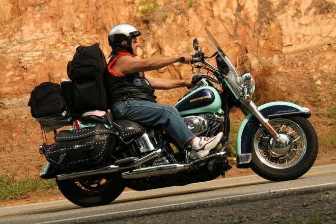
Today started out cool as usual, but it wasn’t long before CA-1 turned away from the ocean and move inland several miles. This helped to warm things up considerably; enough in fact that I was finally able to ride for a while without my chaps and eventually without my leather jacket. Not only did the temperature rise, but so did the elevation. I was riding up into mountainous terrain that was covered by a lush green forest that in many places covered the road with a tunnel of tree branches. The farther I rode the bigger the trees became. By Michigan standard, they were huge, but I knew there were larger ones to come. I was looking forward to riding on the “Avenue of the Giants” today because after hearing about it yesterday, I did some research on the internet last night and that really piqued my interest to want to see it even more. Just before reaching the Avenue, I came to the town of Leggett. This is the town that boasts the “Drive Thru Tree.” Seeing the sign, I had to stop and check it out. The $3 admission charge was well worth the experience. I am really glad I took that slight detour. After a few pictures at the drive thru tree and a “Hot Diggity Dog” [that is what they called it] for lunch I was again on my way to the “Avenue of the Giants.” The Avenue is a 32 mile section of road that parallels CA-101 which takes you through the largest single concentration of original growth redwood forest in all of California. The experience of this drive was just amazing. It is hard to describe the size of these 2000+ year old trees. I am not sure what the experience will be like tomorrow when I ride through the Redwood National Park, but I cannot imagine how the experience can be any better than it was today. While I was researching the Redwood National Park today I also came across other nearby national parks. I discovered that Crater Lake National Park is only about 50 miles from Medford, OR which is were I will be heading tomorrow, so I have added that to my list of “things to see.” Also nearby is the Lava Bed National Monument in Tulelake, CA. I am not sure about going to this one but I will make that call after the Crater Lake visit.

When I started this trip, I decided to bring my computer along for the purpose of maintaining my blog. As the trip progressed, however, the computer has evolved into something much more useful than just that. It became my weather guide as I tried to avoid the thunderstorms and to figure out what to wear the next day. It became a useful research device and trip planner as I tried to figure out what route to take and what distances were between various points on the map so I could plan my next day’s itinerary. Between the computer and my GPS this trip has been electronically enhanced in ways that I never imagined when I first left Michigan two weeks ago. This trip has opened my eyes to a new travel companion that will be with me on all my future trips.

Day 13


Picture 1 is a neat rock outcropping somewhere north of Jenner, CA. Picture 2 and 3 are a coupe of really unusual trees in someone's yard. Picture 4, Do I look happy or what? Picture 5 is another rock outcropping just south of Fort Bragg. Picture 6 is the harbor at Fort Bragg.
This morning I was in San Jose and would be heading north through San Francisco and then over to Bodega Bay to ride along the coast again on CA-1 up to Fort Bragg. The weather at San Jose was pretty nice, but as I approached San Francisco I could see a big cloud bank over the city and the temperature began to drop significantly and there was a dampness in the air making it feel even cooler. I was riding CA-101 into downtown San Francisco toward the Golden Gate Bridge. I could hardly see the bridge because of the clouds that shrouded its towers, but a quick glance over my right shoulder allowed me a glimpse of Alcatraz. Once over the bridge and up the hills in Sausalito, the haze began to burn off and the temperature began to rise again. Once I started to get near the ocean again you could feel the temperature begin to drop. One major difference today, however, is that the sun stayed out all day so it was not nearly as cold as it was yesterday. During the later afternoon, however, the wind did kick up again and it blew relentlessly as I rode to the north.

One section of road just north of Jenner, CA was really twisty. It was up hill with numerous switchbacks. A quick glance at my GPS unit showed a hodgepodge of road just twisting back and forth as it wound its way up the hill. This section of coast north of San Francisco was different than the section south of SF. For one thing the hills and mountains were generally not as high or as rough. A second difference is that it seemed more populated with small towns and homes along most of the way. There were more trees including some really nice sections of redwood trees, but the major redwood sections are still ahead of me. One of the things that I particularly liked about this section of road was that the rivers often created neat little ports that supported small fishing villages. This was especially true at Fort Bragg. There was a wonderful wharf area that was home to a pretty good size fishery and numerous restaurants that sell the catches of the day. They also have whale watching excursions, however this is not the season for that so I guess I would go whale watching.

I met a couple of bikers at the motel today that just rode in from the north. They both highly recommended riding on the “Avenue of the Giants” north or Eureka. They said it is well worth the extra time. They both also recommended that I take Highway 20 north of Seattle. This highway eventually connects with US-2 at the eastern end of Washington which is the road I planned to take back to Michigan anyway, so the Highway 20 looks like a good option to me.

Saturday, July 28, 2007

Day 12


Picture 1, Sea Lions on the beach. Pic 2, One of the many bridges on CA-1. Pic 3 is a tour boat moving in around the kelp. Pic 4 is me outside the Whale Watchers Cafe. Pic 5 is a lighthouse on a rock in the ocean. There are cattle grazing in between the lighthouse and the cars.

This morning the temperature in San Luis Obispo was a cool 54 degrees. The predicted high for areas along the coast was 68 degrees. With the weather being that cool, I put on a long sleeve shirt my chaps, my leather, gloves and leather jacket. As I approached the coast at Morro Bay a mist blew in off the ocean and made the temperature seem even colder. It was down right cold in fact. After riding up the coast for about 30 miles I decided to stop at a restaurant in Cambria to get some breakfast and warm up. I also hoped that maybe the mist would begin to lift if I waited a while. After about 40 minutes I was back on the road again but the chill was still in the air. Every so often, however, the sky would clear a bit and the sun would shine through. But even with that, the chill was still there. Shortly after leaving the restaurant, I came across a place where you could view sea lions on the beach. I am glad they had the signs posted because I would not have known they were there otherwise. There was a whole herd of them just lying on the beach. They were throwing sand on themselves while others played and snorted at each other in the water. There was a guy there that would answer questions and tell you about the sea lions. He said that they come there every year and lay on the beach until they molt. Then they will play around in the water in the area and eventually leave again. They are usually there for 30 days.

After leaving that area the road, CA-1, really began to get twisty, and the mountains to my right were extremely tall, steep, and rugged. It was difficult at times trying to keep my eyes on the road and still enjoy the scenery. Making things more difficult was the fact that I had my camcorder mounted on my handle bars and I was trying to control that as well. I guess this is good training for multitasking. I do think I got some good video, but I have not reviewed it yet. I will do that soon, but as I mentioned once before, I do not have my editing software on this computer so I will not be able to share the videos until I get home. At one point this morning I rode past the Hearst Castle near San Simeon, but I was not able to see it because of the low clouds.

At one of the stops today I met a family that was visiting from England. They were enjoying the trip along CA-1. I also met another biker and his wife. Although he lives near LA now, he was originally from Grand Rapids. His wife had a bike the same color as mine.
About half way to Monterey, I noticed that my new GPS had frozen in one position. No matter what I tried it would not move from that position. Everything else seemed to work fine but it was not picking up a signal from the satellites even though the satellite signals were relatively strong. So there I was riding and multitasking with one more thing. When I got to Carmel I stopped at a gas station and asked where I might find the nearest Circuit City store. Luckily it was only seven miles up the road in Seaside, CA. The guys at Circuit City were very helpful and were able to fix it right away by inserting a wire into the reset hole on the side of the unit.
About 20 miles before I got to Carmel, the wind really started blowing in from the ocean and brought with it another blast of heavy mist and colder air. The winds were really strong and would blast you from all sides. They would hit me on my left and blow me to the right and at other times they would bounce off the mountains to my right and blow me to the left. All of this is happening while the road was getting twistier by the moment.

After leaving Seaside, I headed inland toward San Jose to find a room for the night. After driving about 30 miles the temperature suddenly jumped 95 degrees and I had to stop and take off my leathers. It was a relief to be warm again and also to have my GPS working again. This area of California was really big into agriculture. You could smell the crops in the air. There were major vineyards, cabbage fields, and I even came across and area where the National Garlic festival was going on. I didn’t stop for it but I could pick up the aroma.

In San Jose, I am about 40 – 50 miles south of San Francisco. Tomorrow I plan to pass through San Francisco and then head to the Coast again to follow CA-1 starting at Bodega Bay. I only hope it is warmer along the coast tomorrow than it was today. In two days, I should be at the Redwood National Park in northern California. Then after that I am headed to Medford Oregon where my mother-in-law’s sister lives. I hope to visit with her for a day or two and see some sights in Oregon.

Day 11


Another picture of Lisa, the day I left her house.
I am sorry again for not posting a blog today, but the motel I stayed at did not have a WiFi connection. Tomorrow I will post two. Anyway, I was back on the road again today. My goal was to get through the LA traffic and start heading up the coast. I was also about to turn 3000 miles on the odometer so I also needed to stop for an oil change. Before hitting the road this morning Lisa and I went out for breakfast with a couple of her friends. During breakfast we discussed possible routes for me to get me through LA with the least amount of traffic and to find a Harley dealer along the way. After selecting a route and an appropriate dealer I called ahead to see if they could change my oil that day. Santa Barbara Harley-Davidson in Carpentaria, CA had me in and out in about a half hour. While I was waiting, several of the employees came over and made numerous suggestions about where I should ride if I want to maximize my riding pleasure and witness some of the best scenery.

Carpentaria was only 140 miles from San Bernardino but it took me 4 hours to get there. For the most part, the traffic moved along well, but there were at least four times when the expressway traffic came to a standstill and it was stop and go for several miles at a time. What made it worse was that the temperature was close to 100 again. I guess when you are in LA you just need to put up with traffic problems. One of the things that surprised me most about riding through LA was how many of the towns and street names were familiar to me. I guess it must be the power of television and movies. The towns and streets have become household names.
As I neared the ocean, I could feel the temperature begin to drop. When I crossed the mountains by Oxnard, it felt like someone turned on the air conditioner. I think it went from 100 to 70 in less than a minute. Not only that, but it also looked like someone turned on the Technicolor switch because it went from brown, drab, and dry to green, lush, flowered and full of color.

I rode 270 miles today which took me to San Luis Obispo. I am about 230 miles south of San Francisco. From here I will head out in the morning on US-1 which follows the coast and should start the beginning of some of the most picturesque coastal scenery in the country. I am looking forward to getting some good pictures and hopefully some video as I ride along the coast.

Thursday, July 26, 2007

Day 10


Picture 1 and 2 are of a Route 66 edition of a PT Crusier. It was owned by a couple from Colon, MI. They were traveling Route 66 out to the Grand Canyon. Picture 3 is of Lisa Kovalchik, my niece. Here she is leading her class in from outside.

After 9 days of riding, I finally have a day of rest. As I indicated in yesterday’s blog, I am at my niece’s house in San Bernardino. I will be leaving here tomorrow, but having one day of rest from all the riding is a nice break in the routine. This morning I worked on getting familiar with my new GPS. Although it is very similar to the old one, it is different enough that I needed some practice with it before using it on the road. A couple good features that are different from my old one are that it has a bigger screen, louder sound, and a much sturdier mounting bracket; features that will be very helpful to me as I head down the road.
At 11:30 a.m. today I went to Lisa’s school and did a yo-yo show for the morning kindergarten class and then at 12:30 I did another one for the afternoon class. These were a really big hit with the kids. Afterwards Lisa’s asked if I could do another one for the 1st grade class at about 2:30, and I agreed. In the down time between the shows, I ran to the post office to mail home my old GPS unit and a few other things that I no longer needed. After doing the show for the first graders, I headed back to Lisa’s to wait for her to get out of work. It is another hot one today; about 100 degrees.
Tomorrow I will be heading north to Bakersfield and then across the mountains to the coast. This will help me to avoid the traffic in LA. It will be nice to be on the coast and feel the cool ocean breezes. I hope to get somewhere near San Francisco if I can. While watching the news tonight there was a story that Needle, CA got 7 inches of rain yesterday. There was flash flooding and many streets were closed. I am glad I missed that one.
Now that I have completed my Route 66 journey let me make a few summarizing comments. First of all I will admit that I missed riding some of it, but what I saw was everything I imagined and more. I mentioned before how the smaller towns along the route are like time capsules dating back to the 40s and 50s era. In areas where buildings and features have been restored, these were a sight to behold. In areas where the buildings and sights were abandoned and dilapidated, I was in awe of what these structures once meant to so many people. I can vividly remember my second day on the road as I traveled Route 66 for the first time heading south of Carlinville, IL. Although most of the route was lined with nothing but corn, I imagined all the history of those that had ridden this "mother of roads" before me. I vividly remember physically having goose bumps rise up on my arms. It was one of those unforgettable moments. Although I was no more than a blip on the radar screen of history, the memory of this event will live on in my mind for many years to come. This trip, for me, has made me a part of a historical icon. It may be insignificant to others, but it is monumental to me. Each state has its own highs and lows, good parts and bad parts. For me, the areas that I enjoyed the most were in western Oklahoma, western Arizona, and parts of New Mexico. Some of the more memorable towns were Williams, Seligman, and Oatman, in Arizona. In New Mexico, I enjoyed Tucumcari and Gallup. In Oklahoma, I particularly liked the Route 66 Museum in Clinton. Other memorable moments so far are the two National Parks: the Petrified Forest and the Grand Canyon.
The parts I liked the least were the trips through the bigger cities. In Tulsa, OK I tried to follow the route through the downtown, but I just kept getting off the route and had now idea how to get back on. From that point I resolved to just skip the downtown parts in any of the big cities. The experience in California is mixed. The first part is the Mojave Desert and although, as a "ride," it is somewhat uninspiring; as an experience, I would not have missed it for the world. During my entire preparation for this trip, I kept hearing stories about crossing the desert and I had conjured up all kinds of scary things in my mind. Even during my ride I wondered if I should even attempt it; especially riding by myself. But riding through western Arizona helped to build my confidence, and I felt ready to take on the challenge. I am so glad that I did. For those of you, out there, that are contemplating a Route 66 journey; DO IT! It will be an experience you will never forget.
As a side note regarding my motorcycle; it is a 2002 Heritage Softail Classic. Ever since I bought it my gas mileage has always been between 40 and 44 MPG. In New Mexico, after leaving Santa Fe, my mileage jumped to over 50 MPG. At first I thought it was a fluke, or that I did something wrong, but it has continuously stayed there ever since. My highest mileage was 55 and nothing has been lower than 50 ever since. I wondered if it was because if the higher altitudes, but even after coming down to lower elevations, I am still hitting 50. Can anyone explain this or has anyone else experienced it?

Day 9


Picture 1 is the Route 66 Museum in Victorville. Picture 2 it the Bagdad Cafe which is near Ludlow in the Mohave Desert.
Today I left Needles, CA at about 8:00 a.m. to start my trek across the Mojave Desert. Just a few miles out of Needles I got off the interstate and onto Route 66. The landscape was stark and dry. You could see for miles in every direction. The route was headed north here and I was cruising along at about 60 MPH. In the distance I could see a train approaching and a train-crossing. I wasn’t sure if I would be able to get to the crossing before the train but I sped up to try to make it. I did not want to sit there in the heat waiting for the train. It was only 8:30 a.m. but the temperature was already in the 90s. It looked like I was going to make it so I headed across the tracks. What I hadn’t counted on was the fact that the tracks had a pretty large bump in them. As I went across, I bounced off the seat but did not lose control. Traveling on for another 10 miles I got the first inkling that I was going the wrong way. What tipped me off is when I saw a signed that told me how many miles it was to Las Vegas. What clinched it was when I crossed into the state of Nevada. After checking my map I turned around to find out where I gotten off track. I don’t remember crossing any intersections. After the 10 mile trek back I came to the railroad tracks again but I crossed them more slowly this time. Sure enough, right across the track was where I was supposed to turn. I was so intent on crossing before the train, I didn’t even notice the signs or the road for that matter.
Back on Route 66 again I settled back into my seat and headed west across the desert. As the hours went by, the temperature went up. I did not have a thermometer but I will tell you that it was hot. When I eventually got to my niece’s house (Lisa Kovalchik) in San Bernardino she told me it was 100 degrees at her house and the desert is usually at least 10 degrees hotter. I took ten 20-ounce bottles of water with me for this trip. By the time I got to San Bernardino I had consumed 5 of them; and I was still thirsty. At San Bernardino I stopped at a Wal-Mart and got a 20 ounce diet coke. Soon after that, when I got to Lisa’s house, I took and quick shower and we went out to dinner. There I had another 20-ounce glass of water and an O’Doul’s. Following that we went to the show and saw "Evan Almighty." At the show I drank a 20-ounce lemonade. I finished that off in the first few minutes and kept wishing I had gotten the 60-ounce. When we got back to her place, I drank another 20 ounce diet coke. Guess what? I am still thirsty.
I stopped at the Route 66 Museum in Victorville, but they are closed on Tuesdays and Wednesdays; so much for that.
I think it was yesterday when I was riding just past Kingman, AZ when I felt something hit my leg. I didn’t know what it was at first but shortly after that my GPS gave me a signal that the battery was critically low. When I pulled over to check it out, I found out that then end cover that holds the batter in place had fallen off. Luckily, I had brought along some rubber bands. By stretching a rubber band around the unit and onto the battery, was able to keep it in place so I could continue to use it. Today as I was riding through the desert, I noticed that the GPS was turning on its mount. So I tightened the screw that holds it in place. A little while later it did the same thing so I tightened it again. After a few more episodes of this I decided to stop and check out the problem. As I began to tighten the screw a little more it was apparent that the unit was about to break off. So I stowed the GPS in the saddle bag and continued on my way. I left the mount on the windshield, however, and about 5 miles later the end of the mount fell completely off, and I was not able to find it again. I was really thankful that I had taken the GPS unit off a few minutes earlier or I would have lost that too. With the mount broken, I had to duct tape the GPS to my windshield bag in order to find my way to Lisa’s house. When I got to San Bernardino, I stopped at Wal-Mart and bought a bag of rubber bands so that I could connect it to the bag without the duct tape. After Lisa and I had dinner, we went to Circuit City where I bought a new GPS for the rest of my trip. I would hate to think of trying to make the rest of my journey without one, and the old one would have just been too klutzy to use in the condition that it was in.
I am going to stay one more day with my niece so I will not be traveling on Thursday. She is a kindergarten teacher and they have school year around here. So tomorrow I will be going to her school to do a yo-yo show for her students and another kindergarten class as well; one show in the morning and one in the afternoon.

Wednesday, July 25, 2007

Day 8


Pictures from top to bottom: Williams, AZ; Ash Fork, AZ; Seligman, AZ; Black Mountains in AZ; and Oatman, AZ.


Hello again. I have been receiving several comments from numerous individuals and that is very encouraging to me. After riding all day, it usually takes me all night just to get my thoughts down in the computer and to get it posted to the blogsite. I didn’t expect it to be that much work, but it is fun. Especially when I know that many of you are enjoying it.

Today I got a later start than usual, but not because I was sleeping in. Actually I got up at 6:30 a.m. and after checking outside and seeing a little drizzle I decided to take care of some of my bills that I received notice of electronically. Although that should not have taken too long it ended up taking a couple hours because I could not login to find out how much my credit card bill was. After several attempts with a particularly slow WiFi, I eventually tried to contact the company by phone. Even then it didn’t work so back on the phone again. Eventually I got in and was able to get the amount and make my payment online. What a relief.

It was cool this morning, about 55 degrees in Williams, AZ. It was still spitting a little rain and the sky to the west was really dark. So I got fully suited up for the worst: leather jacket, rain suit, gloves, and Harley boots with plastic shopping bags over them tied at the ankles and then covered part way with the rain pants. I even had the weather tight bag over my suit case to keep that from getting wet. At least if I had to ride in the rain today, I was not going to let it be like yesterday; i.e. getting wet first and then put on the rain suit.

I was on the road for about 5 minutes and it started raining a little harder but nothing like yesterday. Actually it didn’t feel too bad because I was prepared for it. I started out on I-40 because the girl at the gas station told me that Route 66 did not connect to the next town which is Ash Fork. At Ash Fork Route 66 follows within 2 miles I-40 all the way to Seligman. At Seligman Route 66 turns northwest and stays about 30 to 40 miles away from I-40 all the way to Kingman which was about 80 miles away. I was glad I chose this route today because there was a huge thunderstorm that I had been watching and I appeared to be heading right at it until Route 66 turned north at Seligman. I got a few drops, but nothing like what I would have gotten had I been traveling on I-40. About 40 miles past Seligman, there was another major storm approaching from the north. Again, it looked like I was headed right for it until Route 66 took a turn to the southwest to head toward Kingman. Just when I thought I was clear of that one, I came across a guy and his girlfriend who were broken down on the side of the road. I stopped to see if I could be of help. He asked if I had any tools because he thought he fouled a plug on his Harley Sportster. I had a crescent wrench, channel locks, and vice grips. He used the crescent wrench to check the plugs but they were okay. So he checked a few more things and was able to start it. The bad part about all of this was that the thunder storm that I thought I was going to avoid started to come our way. Any he got the bike started and we took off but within about two miles he stalled again so we stopped again. The storm got closer as we searched for the problem. Eventually he came across a vacuum hose that was not connected. He was not sure where it went but when he blocked the hose the bike would run. He then used the inside of a ball point pen to plug the hose and we were able to ride off again. At that point it looked like we were heading directly into a major downpour. Just as it started to rain with some big drops, the road took another turn to the south and directed us around the major part of the rain. Once I got to Kingman, I could tell that most of the storms were to the east of me to I was able to take off my rain suit. I was happy about that because it was starting to warm up.

From Kingman, I stayed on Route 66 to Oatman. At Kingman, you descend from the mountains into a true desert like valley. In the distance you could see another mountain range (the Black Mountains) that looked exceptionally ominous. I wondered if the road would take me around this mountain range or over it. Well it took me over it and let me tell you this was some of the most treacherous riding I have encountered on any of my trips. The road was narrow and twisty. There were numerous switchbacks and in many cases there were huge drop offs on the very edge of the road; in many cases without any guardrails. Back when I was at the Route 66 Museum, I watch a movie that showed some extremely bad road sections. I am quite sure that this is where they took those movies. After a few miles of this I figured that I might want to try to capture some of this on my camcorder, so I found a place to stop and I taped the camera to the handle bars by my right mirror. The problem is there are so many variables to get right: angle, camera settings, zoom, and countless other things which are hard enough to get right under good conditions. These were not good conditions. It was about 99 degrees and I still had my leather jacket on. The camera is wrapped in a washcloth and taped to the handle bar. You can’t see most of the camera controls, much let get at them. I just hooked it up and hoped for the best. On my first attempt the angle was a little bit too far to the right but the video actually turned out pretty good. At one point I stopped to change the angle but inadvertently pushed the zoom button so unfortunately the next section turned out to be very blurry. As I approached Oatman, I noticed that the zoom had been changed so I pulled back the washcloth enough to change the setting. Luckily I did because I was able to get some video riding through Oatman. Oatman is a really neat little town with a whole bunch of little donkeys roaming around on main street.

As I descended from the hills at Oatman, I could see in the distance what I thought was a very large body of water. At first I thought it was a mirage because we were in a desert. But as I approached it I could tell that it was really water. It turned out to be the Colorado River. The same river I saw the day before at the Grand Canyon but then I was 5000 feet above it. At the canyon the river looked muddy, most likely because of runoff from the recent rains. Here, at the California border the river was quite blue and beautiful. Earlier today when I was crossing the desert in the valley between two mountain ranges, there were numerous signs that warned travelers not to cross if there was water flowing across the road. These areas were major dry washes. One was named the Sacramento Wash. As I approached the Colorado River I came across the other end of the Sacramento Wash at the point where it emptied into the Colorado River. All along the river there was a very heavy plant growth of some of the most twisted looking trees that I have ever seen. There was evidence everywhere that there must have been many times when the Sacramento Wash was a raging torrent of water that just ravaged this vegetation. I was glad that there weren’t any flash floods going on while I was there.
Today's ride was a total of 240 miles and probably about 210 of that was on Route 66. My hat's off to Arizona for there exceptional marking of the historic highway. I never got lost or off track once today, or anywhere in Arizona for that matter. I can not say that for all of the states I have been through.

Anyway I crossed over the Colorado into California and got a room at Needles, CA. Tomorrow I am heading to my niece’s house in San Bernardino which is about 250 miles away if I take Route 66. Most of this will be across the Mohave Desert. I hope I can get an early start.

Tuesday, July 24, 2007

Day 7


This morning started out to be a beautiful day. It was cool but sunny and I was heading up to the Grand Canyon. As I got nearer to the Grand Canyon you could see some dark clouds and lightning off in the distance. When I got to the east gate of the south rim the sun was still out but the clouds getting closer. I stopped at the first overlook for my first look at the Grand Canyon. I have to tell you, it was spectacular. I could actually begin to feel my breathing change as I got closer. This place is so overwhelming; it takes your breath away. I took numerous pictures but none of them can do it justice. Anyway, I headed off to the next overlook and it was even more spectacular. As I headed to the third overlook, I felt a drop of rain and wondered if I should stop to put my rain suit on or just head to the next stop and do it there. Well I decided on the latter and that was the wrong decision. I no sooner got out of the parking lot and onto the road and the sky just let loose. The road at that point had no shoulder so it was not possible for me to stop to put on my rain suit. So I just continued on until the road finally widened. At that point I was pretty soaked but I put on my rain suit anyway. After getting to the next overlook I sat under a sign that had a small roof over it. After about an hour the rain slowed enough to take a few pictures and head to the next few overlooks. It was lightning and thundering really bad. At one of the overlooks, there was a guy there who said, “it’s going to lightning again because my hair is standing on end.” Sure enough it was standing on end and the lightning did come. It was really strange; his hair would rise up and then go down again.

After getting a few more pictures I decided to leave. Just as I was leaving the park the rain came again really strong and the visibility was really bad. A few miles south of the canyon’s south gate, I rode into a small village and decided to stop at the National Geographic Center to try to wait out the rain. There is an IMAX theater there so I decided to see the Grand Canyon on the IMAX. I had to wait for 50 minutes for the movie to start and the movie was 35 minutes long so I was hoping the rain would pass by that time. Well, no such luck. It was still raining when I got out but it was a little lighter. In the movie I sat next to a gentleman from Australia. He has been in this country since February and is just traveling around the country seeing all the sights. He will be heading back soon because he only had a 6 month visa. I also met a guy from Chile who was in this country with his wife and daughter and they are traveling on motorcycles seeing all the national parks. It is amazing how many foreigners there are at national parks. I think they vastly outnumber Americans. Today I met people from Switzerland, Holland, Sweden, France, and Germany today. In addition, the Japanese are all over the place.

After leaving the National Geographic Center, I rode in the rain for about 15 minutes and then it finally started to clear up a little. I got a motel in Wilson, AZ. This is another of those really quaint Route 66 towns. Tomorrow I should get to the California border and on Wednesday I should arrive at my niece’s house in San Bernardino, CA.

Sunday, July 22, 2007

Day 6


Picture 1 is the storm I rode into yesterday in NM. The other pics are all in the Petrified forest.
Well today was a great day. It was partly cloudy this morning and a little cool but in short order it warmed up really nice. I left Gallup, NM at about 9:00 a.m. and got to the Painted Desert and Petrified Forest National Park at about 9:00 a.m. There was a time change in AZ so the one hour ride didn't take me any time at all. Once I arrived at the national park, I took off my leather jacket because the temperature had risen into the 80s. At the entrance I purchased a senior annual pass for $10. What a bargain; access to all the national parks for $10. At the information building, I met another couple on a BMW motorcycle. They were from Germany and were touring several of the national parks. A little while later I came across another couple from Germany. Each of them was riding rented Harley-Davidson's. I felt sorry for them because they each had on black leather pants and black shirts and the temperature was now approaching 90.

The Painted Desert and the Petrified Forest are very much like the Bad Lands in South Dakota. They are some of the most inhospitable of landscapes but they are breathtakingly beautiful. At the Petrified Forest end of the park the petrified trees are amazing. There is one that has even formed a natural bridge over and ancient dry wash. Some of these trees are huge; probably 6 to 8 feet in diameter. About half way through the park, I had to stop to change into my sleeveless shirt and shorts. It was really getting warm but there was at least a nice breeze. The one guy from Germany on the BMW still had his jacket on so I asked why? He said he had all his valuables in it and was afraid that he might lose it. I think I would by a fanny pack for my valuables.

After leaving the park I got back on I-40 toward Flagstaff, getting off to cruise through each of the small towns along the way on Route 66. These towns are like time capsules that date back to the 50s. It is just amazing.

As I neared Flagstaff, I could see some clouds and thunderstorms getting closer. About 20 miles out the temperature had dropped considerably and I was still in my shorts. As I neared Flagstaff I could feel a few drops of rain. I got a room right away and unpacked the bike. After running to the store for some supplies I headed back to the room. I let the bike cool down for about a half hour and then covered it with the rain cover. Within 30 minutes, the rain started. Now that is the way it is supposed to happen on a bike trip. I guess I must have done something wrong yesterday to get caught in the rain the way I did.

Tomorrow I am heading up to the Grand Canyon which is 93 miles north of here. The Flagstaff weather for tomorrow is predicted to be a high of 71 with scattered thundershowers. Hopefully, they will all scatter to the south.

Several of you have written comments to my blogsite and I want to thank you for that. It is nice to know that people are actually reading it. This is actually a lot of work. One night I was up until 1:30 a.m. working on it. I am not sure why the comments are not showing up on the blogsite itself, but today some of them came to my email. I received comments from Dan Dellar, Connie Wright, and Aaron Bohjanen. Thanks to each of you. I tried to respond to the emails but that didn’t work because it comes in as a blogspot.com email.

Day 5


This morning I road from Tucumcari, NM to Santa Fe. The weather was great this morning; partly cloudy and about 80. As the rose higher, I also was heading up to a higher altitude which kept the temperature from getting oppressively hot like it has been the last few days. At one point today I checked the altimeter on my GPS and it read 7,340 feet above sea level. This was just about 30 miles from Santa Fe. In Santa Fe itself the altitude was about 6,800 feet. I arrived in Santa Fe at about 1:30 p.m. I headed directly to the visitors center to what was available there. The town of Santa Fe is really nice looking. Pretty much every home and building is an adobe type constructed building. The visitor’s center was right in the center of town which was build many years ago, thus the streets are very narrow. Being there gave me a somewhat claustrophobic feeling. My intent was to stick around town and check out some of the sights, but instead I decided to head back out on the road. I decided to try to get as close to Arizona as I could because I want to stop at the Petrified Forest and the Painted Desert in AZ. Not too long after getting by Albuquerque I could see several thunderstorms looming on the horizon. As they got closer, the temperature began to drop. Eventually it became apparent that I was not going to miss the rain so I stopped to put on my rain suit. I no sooner got it on and I began to feel a few rain drops. Within a minute it was a major downpour so I stopped under an overpass. After about 45 minutes the rain slowed a little. You could see that the main storm was moving to the south but there was another one coming in from the north. I got back on the bike to see if I could get to Gallup, NM, which was about 60 miles ahead. As the one storm moved off, there was only a brief slow down in the rain. The other one was only minutes away and it started raining again. Eventually I made it to Gallup and found a motel. It continued to rain for another 2 hours but then is slowed down enough to get out and wipe down the bike and cover it with the new rain cover that I bought a couple of months ago.

On the way to Santa Fe, I tried out the helmet cam. That is, I duct taped my Sony Camcorder to my helmet and took so videos of a very scenic drive along old Route 66. This time I even tried narrating a little as I drove and took videos. When I checked it out tonight I found out that I had the camera pointed too high, so all I have is pictures of the sky and the clouds. That is disappointing, because the place was really neat looking.

Other than for the rain today, it was a really good day. No breakdowns of any kind.

Because it was raining when I got hear I forgot to check the odometer to see what my miles driven were, but I know that not too long before getting to Gallup, my odometer turned 24,000. This would mean that I traveled about 500 miles today and overall a total of 1900 in the 5 days.
The picture of the Cross is in Groom, TX. It is 190 feet tall and is said to be the tallest cross in the Westeren Hemisphere.

Saturday, July 21, 2007

Day 4


Current I am in Tucumcari, NM. The temperature seemed a little cooler today because there were a few clouds in the sky, but even at that the temp was 92 when I pulled into Tucumcari at 5:45 p.m. I managed to travel 386 miles today. For the four day, I have traveled 1520 total miles and have been in the following states: Michigan, Indiana, Illinois, Missouri, Kansas, Oklahoma, Texas, and New Mexico. I have passed the midway point on Route 66 which is in Adrian, TX. Today I did most of my traveling on I-40, getting onto Route 66 only when there was a known interesting site to see. I decided to stay on the interstate to cover more ground today because, quite frankly, the scenery in Texas and Oklahoma leaves a lot to be desired.

Tomorrow I plan to head up to Santa Fe, NM. I have been told that it is a fantastic city and the scenery getting there is a vast improvement over what I have been through the past several days. It is only 167 miles from Tucumcari, so I should be able to get there early enough to enjoy the town.

Today I was able to see some pretty neat stuff even though most of my time was spent traveling on the interstate highway. In Texas, I passed by a really huge herd of cattle. I have to say that I smelled it before I saw it. There must have been thousands of them in one group and there were several more groups farther down the road.

The highlight of today was my visit to the Route 66 Museum in Clinton, OK. They had some really neat memorabilia and they also showed a film of the history of Route 66 that was just fascinating. It even included a clip from the Route 66 TV show that starred George Maharis and Martin Milner. You old timers should remember that.

One thing I forgot to mention the other day was having passed a place called “Spanish Echo Farms.” The name intrigued me so I thought I better stop and check it out. From the side of the road I cupped my hands around my mouth and yelled out, “HELLO,” and a second later the echo came back, “HOLA.” So then I shouted, “GOOD BYE,” and the response came back, “ADIOS.” On a third try, I shouted, “CONGRATULATIONS,” and the response was, “______.” I suppose that is because I don’t know that word in Spanish. Now this may not be exactly how it happened, but that’s my story and I am sticking to it.

So far, ever day has had some kind of problem and today was no different. This morning when I went to start the bike the key fob that unlocks the electronic anti theft system would not work, no matter what I tried, the antitheft system would not shut down. I finally had to enter the pass code using the turn signals to get it unlocked. I headed directly to the Harley dealer to see what was wrong. The service manager told me it was interference from a radio tower that was right across the road from the dealer and only 2 miles from my motel. The signal from it also messed up my GPS for about 12 more miles. A second problem occurred just outside Amarillo, TX. My GPS quit working because it wasn’t charging and the internal battery died so it shut down. Apparently there was something wrong with the connection to the battery. I stopped at an auto parts store in Amarillo and bought a circuit tester to track down the problem. After fiddling with it for several minutes I was able to get it connected and charging again. I hope that if I have any other problems on this trip, they end up being small ones like this.

Have a good day. I know I will.
Picture 1 is the Route 66 Museum in Clinton, OK. Picture 3 is of an old restored Philips 66 gas station in Mclean, TX.
By the way, I am staying at the Tucumcari Inn in Tucumcari, NM. Although it is and older motel (1950s vintage) it had one of the cleanest and nicest rooms so far and it is the cheapest room so far as well. The price, including taxes, was $30.50. I would recommend it to anyone who passes through this way.

Thursday, July 19, 2007

Day 3


Sorry I didn’t post a blog today. I had it already to go, but then I lost my internet connection. The temperature today was 96. I traveled 320 miles.

This morning at breakfast I met a lady from Belgium. She came to America with her niece for the sole purpose of traveling from Chicago to LA on America’s Mother Road, Route 66. She said that it has been her dream since she was 18 years old. I would guess her age at 60 – 70 now. She was so excited about her trip. She indicated how the freight trains that ran along side Route 66 fascinated her because she could just imagine how the people of years ago would just hope on them and ride to wherever it took them.

My route took me from Springfield, MO to Oklahoma City, OK; a total of 320 miles. I improved my skill at staying on Route 66 with the use of my GPS. Previously, I had preprogrammed various stops on Route 66, buy quite often there were many miles between these sites, so the GPS would want to take me to my destination but it would use a different route taking me of Route 66. To counteract that I started programming in, sites that were much closer together. Close enough in fact, that the GPS had no choice but to stay on the road I was on. As a result, I got to see a whole lot more of Route 66 than on previous days. Another advantage today is that Route 66 highway was much farther away from I-44 so it was easier to keep from being directed back to the interstate.

The major cities are another problem. Trying to find your way through them while staying on Route 66 is quite difficult and I would also add, it is also the least satisfying. I think from now on, I will take the interstate highways around the bigger cities and then reconnect to Route 66 on the other side of the city.

Today I got to see some neat attractions along the way. Among them were a pond with a big Blue Whale in it, an abandoned castle, and a beautifully restored Sinclair station.

Wednesday, July 18, 2007

Day 2


What a day. I got up in the morning and the weather looked great. I cleaned off the bike from the wet ride on Tuesday and got everything packed up to go. My plan was to head out back to Carlinville, IL and get on IL-4 which is Route 66 heading to St. Louis. After taking a few pictures in Carlinville, which has a really picturesque town square. After a few pictures, I headed south on Route 66. Although there are signs telling you that you are on Historic Route 66, the signs are really few and far between and it is easy to get off track. Having gotten off track a few times as I neared St. Louis I figured I would just head toward the Mississippi River, get to Missouri, and try to get my bearings from there. In Alton, IL I got on a bridge to cross the river just north of St. Louis. As soon as I got to the Missouri side I could feel the rear tire begin a very unsettling wobble. I immediately thought, "flat tire," and sure enough it was. I was doing about 50 mph when I first noticed it but I was able to get the bike slowed down without any incident. It was 11:00 a.m., 95 degrees, and here I was stuck on the side of the road. I immediately took out my cell phone and my HOG card to call for road side assistance. The lady from HOG was really great and within 5 minutes she had all the information she needed. With the 95 degree heat I needed to get out of the sun while I waited, so I walked up a hill and settled down in some bushes. At 11:45 the truck showed up. I was amazed that they got there that quickly. The driver loaded me up and by 12:30 he had me at Doc's Harley-Davidson in Kirkwood, MO. As we were in route to the dealer, he called ahead and arranged to have my bike worked on right away. By 3:15 p.m. I was back on the road again. I cannot say enough about the great service that HOG Road Side Assistance provided and Doc's Harley-Davidson. Following that ordeal, I got back on Route 66 with the hope of making Springfield, MO which was about 210 miles away. This was short of my goal for the day, but it would put me back on track without too much lost time, but reaching Springfield would be a stretch if I stayed on Route 66 for the entire time, especially since it is not always clear where Route 66 is at all times. Every once in a while 66 just dissappears and you need to get on I-44. After a few times of that happening, I decided to stay on I-44 for the last 90 miles so that I could get to Springfield before 8:00 p.m. Hopefully tomorrow will be less eventful. I will say this though, "I would rather put up with the inconvenience of a flat tire than to be back at work. Retirement is great and inspite of the difficulties of the first two day, I am having a GREAT TIME."


Tuesday, July 17, 2007

Day 1


Finally I got underway on my trip after a 4 day delay. My anticipation was high but a check of the weather in the morning showed that if I stuck to planned route, I was in for some really wet riding on my first day. Immediately to my south in Michigan and Indiana was a pretty large thunder storm and heading toward Chicago was an extremely large storm cell that was heading southwest. Between them there appeared to be an opening, that if I was lucky, I could head south into central Indiana and possibly avoid both storms. If I stuck to my plan and headed toward Chicago and Route 66 there would be no way to avoid the major storm that was headed in from the west. This storm was packing heavy rain, hail, flash flooding, and high winds. So instead of heading to Route 66 at Joliet, IL, I decided to turn south at Michigan City, IN and hopefully avoid the major storm. As I approached the Michigan state line, it started to rain and it progressively got harder as I got to Michigan City. In Michigan City I headed south on IN-421 which goes straight south to Lafayette, IN. The farther south I got the lighter the rain became; eventually turning into a light drizzle. After about 70 miles of rain, the sun began to peak through. At Crawfordsville, IN I headed west to Springfield, IL and then to south Carlinville, IL where I eventually got a room at the Carlinville Best Western at about 8:00 p.m. Michigan time. This was an 11 hour ride that covered about 540 miles all together. I am sure that I have missed a lot of great sights along Route 66 from Chicago to Carlinville, but with the rain I am not sure that I would have enjoy it much any. In any event I was able to see a whole lot of corn growing in Indiana and Illinois. Needless to say, with the rain and all the corn, I did not get to take any pictures. The weather report for tomorrow is 95 and sunny. Hopefully more conducive to sightseeing and picture taking.

Monday, July 16, 2007

What next?


Monday morning and I went to the doctor to get my blood pressure checked to see if I could leave today. It was moderately high but the doctor gave me permission to leave. Then it started to drizzle so I checked the weather channel. They indicated severe thunderstorms for today for the Chicago area, so I did some checking on line and it appeared that if I left right away, I might pass by Chicago on my way to Springfield, IL before the storms got there. So I got everything packed and headed out. I got about 8 miles out when I noticed my check engine light come on. I stopped to check my oil and other obvious things and everything appeared to be fine. I started the engine and the light was off. So I headed south again but within a few miles the light came on so I turned around and headed home. I called Hot Rod Harley in Muskegon and they said they could check it out at around 4:00 p.m. today. So I loaded it on the trailer and headed down to Muskegon. Assuming that they find and fix the problem, I will try to get my trip started on Tuesday. I hope the rest of the trip goes better than the start.

I just got back from Muskegon. Their diagnostic computer identified the problem with the coil or the plug wires. The guy tested the plug wires and found them to be OK, but noticed that the one wire was not connected securely to the coil. This would account for the engine light coming on and going off intermittently. After a short test ride this evening everything seems to be in good working order so I have everything all repacked and ready for an early start tomorrow morning. I just pray that nothing else happens.

Friday, July 13, 2007

Getting a late start


Today was to be the day I started my two month motorcycle trip out west. Unfortunately, I saw the doctor yesterday and he discovered I had some high blood pressure. He is a new doctor for me and this is the first time I had ever seen him. He wanted to check my pressure again this morning, Friday, before I left. It was better but still up some so he wanted me to start on some pills and see him again on Monday. Hopefully he will give me the green light to leave on Monday. As you can see in the picture, I was all packed and ready to go. Maybe this is a good thing. Everyone told me not to leave on Friday the 13th anyway.


Jerry

Wednesday, July 11, 2007

Helmet Cam Video of the Blue Ridge Parway

Just north of Ashville, I decided to try to take some video while riding the Blue Ridge Parkway, so I duct taped my Sony Video Camcorder to my helmet and took some video. It actually turned out pretty good. Click on the link below to see the video.

Sunday, July 8, 2007

Blue Ridge Parkway (BRP) Trip - July 22 to 31, 2006


Introduction:

My goal on this ride was to head south from Ludington, MI and get on the Blue Ridge Parkway (BRP) in Cherokee, NC. I would ride the Blue Ridge its entire length (469 miles) from Cherokee to Waynesboro, VA. In Waynesboro I would continue on to ride the entire length of the Skyline Drive in the Shenandoah National Park in VA. This runs for 105 miles and ends in the town of Front Royal, VA. Both the BRP and the Skyline are without any stop signs their entire length. However, this does not mean you never stop. With their abundances of beautiful vista and scenic overlooks, it is difficult to ride more than a few miles without stopping to enjoy the beauty.